Of the different types of units within the National Park Service, National Lakeshores are some of the rarest. Just three instances of recognized lakeshore exist. You will not be surprised to learn they all occur within the Great Lakes, though just two of those five majestic bodies of water feature a National Lakeshore. One occurs on Lake Michigan and the other two belong to Lake Superior, the lake so big it could be an inland sea.
One of the nation’s and world’s best-kept natural secrets forms the border between Lake Superior and the Upper Peninsula of Michigan. In most spots, lakes and oceans meet land in rather gradual ways, beach ceding to waves. In some wonderful instances, the connection offers a rather stark barrier. The Cliffs of Moher are a sterling example. Pictured Rocks National Lakeshore is 42 miles of gorgeous scenery along Lake Superior. The name comes from 15 miles of sandstone cliffs that rise as much as 200 feet above lake level.
At times, these cliffs appear to be the canvas of the Great Artist of the Cosmos.
The location of Pictured Rocks along the shores of Lake Superior - image from ResearchGate
A snippet of sandstone cliffs - photo by Kyle Stout
Pictured Rocks became the country’s first National Lakeshore in 1966. The lure of the cliffs to humans dates much further into the past.
Lake Superior is a perilous body. It’s so massive that waves have topped 30 feet in height, a monstrous figure for a non-ocean. Add soaring cliffs to this notorious chop and Pictured Rocks can be tricky to navigate. No wonder in 1658, as French fur trader Pierre Esprit Radisson traveled through the area with indigenous guides, he noticed them making offerings to the spirits of the cliffs. Though dangerous, we have long admired their beauty. In 1820, geologist Henry Rowe Schoolcraft noted the region as “some of the most sublime and commanding views in nature.”
Indeed, Schoolcraft preaches truth. The sea caves, arches, blowholes, turrets, stone spires, and glittering colors are a true marvel. Time and tide have crafted 15 miles of unexpected glory along the shore.
Erosive hollows at golden hour - photo by Deborah Stout
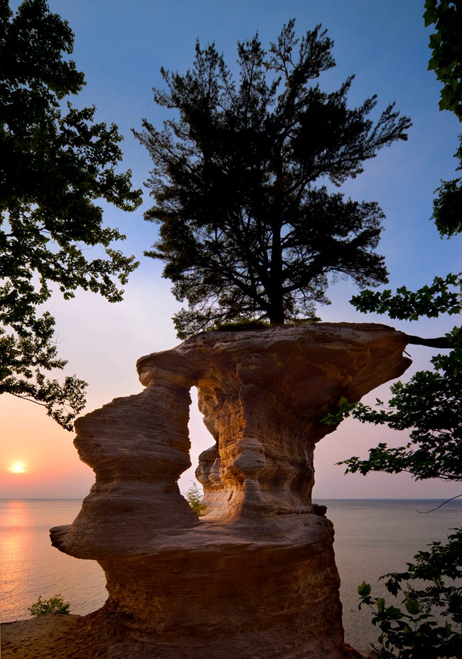
Chapel Rock - photo by Craig Blacklock
Life finds a way at Chapel Rock - image by Kyle Stout
The two images above are different perspectives of Chapel Rock. This spot exemplifies the concept of “life finds a way” better than any spot I have visited. The white pine atop the rock manages to survive with a root grasping to lifeblood on the shore proper. The National Park Service estimates this tree is over 250 years old. The piece of rock connecting Chapel Rock to the rest of the cliff collapsed sometime in the 1940s. For nearly a century, this white pine has hung on.
Peculiarities such as Chapel Rock dot the entirety of the cliffs. Some prominent features resemble castle turrets or human visages.
These cliffs are literal histories of the earth. Starting sometime between 500 and 800 million years ago, sediments from ancient seas formed layers of rock. In this region, Jacobsville Formation sandstone creates the oldest, bottom band. On top of that is the Munising Formation conglomeration, which appeared 400 to 500 million years ago. The crown of the cliffs is the Au Train Formation, an extremely resistant sandstone that allows us to experience the cliffs today.
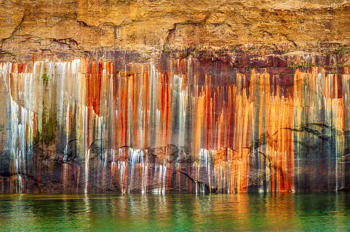
These rocks burst with minerals. When combined with groundwater runoff, the minerals produce vivid colors. When the colors decide to create streaks, Picture Rocks really spring to life!
Streaks at Pictured Rocks - photo by Craig Blacklock
Brushstrokes on rock - image by Deborah Stout
Kayakers and colors - image from Munising.org
Photo by Craig Blacklock
Photo Credit - Jason Paul
According to the U.S. Geological Survey, iron produces red and orange streaks; manganese makes black and brown; limonite propagates whites; blues and greens stem from copper.
Of course, the lakeshore contains 27 miles of non-cliff resplendence, as well. Waterfalls abound, including the notable Bridalveil Falls, Sable Falls, Munising Falls, and Miners Falls. The Grand Sable dunes produce another imposing barrier between water and land, in parts rising even higher than the tallest cliffs.
On land, trails to the tops of some of the cliff highlights and waterfalls provide an opportunity to see a slew of critters and ancient trees.
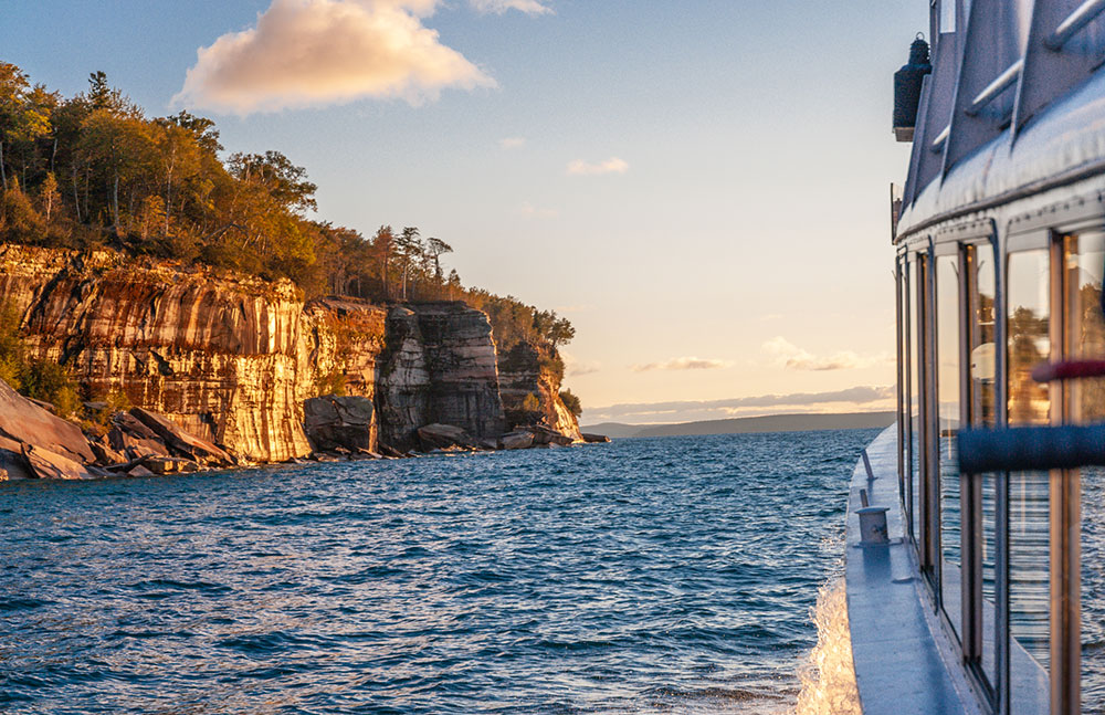
The highlight of any trip, however, should be a boat tour of the cliffs. The sunset voyage is particularly lovely. Lighthouses yield to sublime natural wonders. If you’re lucky, the colors on the rocks will match those of the sun dipping beneath the watery horizon.
A view from Pictured Rock Cruises
Lovers Leap - photo from NPS
The snapshot we have today is, of course, temporal. The elemental forces that carved beauty into the sandstone at Pictured Rocks will invariably take them away. Numerous notable aspects of the shore have already dissolved into Lake Superior.
Because we live in the technological age, we have visual evidence of this process. The following videos illustrate the power and the scale of these cliffs.
Make sure to visit these locations. They won’t be around forever!


Pingback: Second Anniversary Issue – themountainsarecalling.earth
Pingback: Life Finds a Way // Chapel Rock – themountainsarecalling.earth