In 1803, the United States added a 17th member to its fledgling union. This region has many nicknames, including the Buckeye State and the Mother of Presidents, but its official name – Ohio – comes from the mighty river that forms much of its eastern and all of its southern borders.
Erie, one of the Great Lakes, forms most of the state’s northern boundary. Though infrequently considered a border state, Lake Erie’s waters separate Ohio from the Canadian province of Ontario.
Across the Ohio River are West Virginia and Kentucky. Additionally, arbitrary lines make Ohio neighbors with Pennsylvania, Michigan, and Indiana, bringing the total state borders to five.
Ohio and its neighbors - map by Kirill Shrayber
Ohio River near Powhatan Point - photo by James St. John
Cincinnati skyline along the Ohio River - photo by Kaleeb18
Frozen Lake Erie - photo by rabesphoto
Lake Erie from the International Space Station - NASA
The first “frontier” of the United States, Ohio became a key cog in the nation’s rise. In addition to the aforementioned presidents (seven of America’s chief executives were born in Ohio), the state produced the three most significant Union generals by the end of the Civil War (Grant, Sherman, and Sheridan), the Wright Brothers, aviation pioneers, and, perhaps, the two most important astronauts, John Glenn, the first American in orbit, and Neil Armstrong, the first person on the Moon.
Yet the state’s name belies a human presence far before Europeans arrived on the continent. “Ohio” is an Indigenous word, arriving from the Seneca word ohiːyo’, which means “good river.” The Ohio served as a bloodline for numerous civilizations and groups over thousands of years. Evidence suggests humans might have inhabited the land that now constitutes Ohio as early as 13,000 BCE.
By 1,000 BCE, the Adena culture had taken root in the region, producing semi-permanent settlements, thanks to their ability to domesticate crops. The Adena began a rich heritage in Ohio – and other places in the modern Midwest – of crafting earthen mounds on the land. The Hopewell people, who succeeded the Adena, took this art to a massive scale, producing the largest earthen complexes on the planet, many of which served as solar and lunar clocks, observatories stitched into the land. The subsequent Fort Ancient peoples continued the tradition. Though many of the structures were destroyed during European settlement and industrialization, key sites remain, including the Great Serpent Mound in Adams County, the Great Circle, and the Octagon, both at the Newark Earthworks.
The scope of the earthworks in Ohio is so massive that UNESCO designated the Hopewell Ceremonial Earthworks a World Heritage Site in 2023.
The Great Serpent Mound in Adams County - photo by Eric Ewing
The geometric layout of the Newark Earthworks, mapped by Squier and Davis in 1848
The ranges of prehistoric cultures in the Ohio region - graphic by Heironymous Rowe
While Ohio lay at the intersection between the “old” colonies and the western frontier, the land had already served as an interstice for a much more ancient process.
Much of the state’s topography owes its nature to glaciation. Traditionally viewed as a flat state, Ohio’s western zones live up to this connotation. Massive glacial walls left the land fertile and largely even, which today can appear to be vast oceans of corn and soybeans.
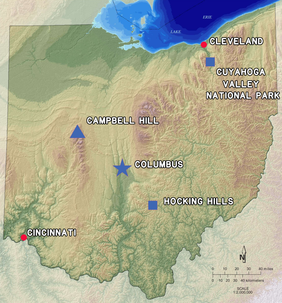
But the ice stopped its eastward advance just past the midpoint of the state. The southeastern portions of Ohio form the Allegheny Plateau, the opening salvo of the Appalachian Mountains. This section of the state features full-fledged Appalachian relief, as forests sit atop rugged ridges that feel more akin to West Virginia than farm country.
Farther north, through the urban areas of Akron and Cleveland, sits Cuyahoga Valley National Park. Once the paragon of pollution, the Cuyahoga River has morphed from a waterway that might catch fire to an area of preservation, becoming the state’s only National Park.
Geographic regions of Ohio - graphic by Mortadelo2005
Glacial striations on Kelleys Island - photo by James St. John
Lower Falls, Old Man's Cave, Hocking Hills - photo by Kyle Stout
Balanced Rock, Hocking Hills - photo by Kyle Stout
Whispering Cave, Hocking Hills - photo by Kyle Stout
Blue Hen Falls at Cuyahoga Valley National Park - NPS photo
The High Point of Ohio, Campbell Hill, is ironically outside of the Appalachian foothills. In the glaciated northwestern portion of the state, Campbell Hill is an example of bedrock reaching the surface. Its composition is so much harder than the surrounding areas that it managed to resist some of the glacial chisel. At 1,549 feet (472 meters), it ranks as the 43rd-highest state acme.
Demonstrating that nature takes the path of least resistance, the lowest point in the state occurs where the Ohio River meets Indiana and Kentucky, as water flows downward toward the Mississippi.
Ohio ranks 34th of the 50 states in terms of size, covering 44,825 square miles (116,096 square kilometers), which is slightly larger than Bulgaria and Iceland, slightly smaller than North Korea and Malawi. The seventh-largest population resides within Ohio’s borders, as of 2026, making it the tenth-most densely populated state.
The Buckeye nickname comes from the state tree, Aesculus glabra, whose nuts resemble deer eyes. The white-tailed deer, perhaps not coincidentally, is the state mammal.
Other fun flora and fauna you might encounter in Ohio include the red carnation (state flower), the great white trillium (state wildflower), the pawpaw (state fruit; it’s citrus!), ladybugs (state insect), spotted salamanders (state amphibian), and black racer snakes (state reptile). If you’re really lucky, you might run into the eastern hellbender, the third-largest amphibian in the world, which can grow up to 27 inches long; unfortunately, it’s endangered.
Ohio buckeye tree - photo by Isfisk
Buckeye nuts; don't confuse them for chestnuts - photo by Porsche997SBS
Great white trillium - photo by CCCP
Pawpaw tree and fruit - photo by Scott Bauer, USDA
Eastern hellbender - photo by Brian Gratwicke
Ohio touts a surprising amount of variety for a state with a bland reputation.
From the Good River to a Great Lake, through stunning gorges, the Buckeye State has a legitimate claim to being the “Heart of It All.”