Arcus Clouds
The second full week of June produced some extreme weather across the United States. Yellowstone National Park endured a 200-500 year flooding event that swept away homes in the overfull rivers and might keep the area closed to visitors for months. A heat dome covered much of the country, producing triple-digit Fahrenheit temperatures. And that heat prompted a slew of powerful storms across the Midwest, including some derechos. Here at The Mountains Are Calling Headquarters in Central Ohio, the tempests managed to knock out electricity for many thousands of people for the better part of a week. A lack of air conditioning during a heat dome does not make for a pleasant or safe experience.
In addition to large amounts of precipitation, derechos pack incredible winds. These storms are mighty and unforgiving, but they can also produce terribly beautiful conditions.
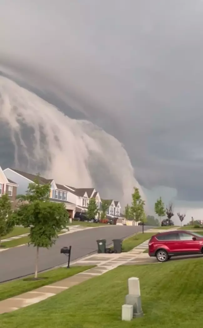
For example, the recent storms produced this cloud in the Cincinnati area [editor’s note: the video we had originally aired here no longer functions, so this photo will have to do; you can view a version of it here]:

The suburbanites experienced an arcus cloud.
The original poster online wrote that they thought they had witnessed a tsunami! Obviously, that phenomenon would be tough to encounter in Southwestern Ohio, but the description of the optical illusion is certainly apt.
Arcus clouds are low, horizontal formations. They usually accompany cumulonimbus clouds, the big, bad members of the wisp world that produce thunderstorms and often appear to be mushroom clouds. Arcus clouds typically present as the vanguard for terrible squalls. They commonly appear in two different forms: roll clouds and shelf clouds.
The example in the video above is a shelf cloud. These happenings are as gorgeous as they are terrifying.

A shelf cloud is the result of the recipe that makes storm clouds in the first place. They happen on the gust front of storms, where the cool air in a cloud’s downdraft hits the land. This sinking air undercuts warmer air that the system sucks into the updraft. As the cool and warm air combine, water condenses, which forms a new cloud. These nascent clouds are prone to wind shear, which causes them to contort, ball, and twist into a gnarly shape that can somewhat resemble a shelf.
Shelf clouds can produce some precipitation, but they are really the warning of the fun to come. Though they appear to some like a wall cloud – the formation that accompanies tornados – wall clouds usually transpire on the back end of storm cells.


The second type of arcus cloud – roll clouds – are rarer.
Unlike shelf clouds, the roll version is not connected to a parent cloud. These detached beauties form tubular shapes and seem to be rolling. They are technically solitons, a type of wave. They have only one crest and move along without altering speed or shape.
Though roll clouds can form over land due to thunderstorms, they more frequently materialize over water. In Queensland, Australia, typically in October, roll clouds form often enough to garner a proper name: the Morning Glory Cloud. The winds in the Gulf of Carpentaria are perfect for roll clouds. Other coastal areas, such as California, the English Channel, the North Sea, and Alaska receive roll clouds, too, though less often.
These clouds are truly spectacular:


Roll clouds are inherently less dangerous than their shelving cousins. Both types illuminate the glory of the natural world, but if you encounter a shelf cloud, note its resplendence and then get to a safe spot. Chances are a big storm is hiding behind the drawer!
Further Reading and Exploration
Arcus – International Cloud Atlas
Volutus (Roll Clouds) – International Cloud Atlas
Shelf Cloud vs. Roll Cloud – Weather Savvy
What are Arcus Clouds – Higgins Stormchasing
Morning Glory Cloud – Morning Glory Australia


