
The Scale of Disaster
[Editor’s note: This article contains video that likely displays the loss of human life. None of the video features granular details, as it exhibits events from a distance. Still, if you have trouble with this sort of topic, please consider skipping the videos. We decided this topic is important enough to post the evidence, as these types of natural disasters will likely become more common in the future. We owe it to these victims and our fellow humans to educate ourselves on the changing nature of the planet.]
On 26 August 2026, a monumental flood devastated areas along the Trishuli River on the border of Nepal and Tibet.
In the aftermath, commentators bandied the term “biblical” to describe the deluge.
Though humans have become accustomed to localized natural disasters, we have difficulty comprehending the scope of larger events. The notion of a flood might conjure waterways overflowing banks, inundating roadways, or filling basements, but how big is a “biblical” event?
On massive scales, words and measurements can overwhelm our brains. The figures of the Nepal-China flood are incredible, but this event provided us with the modern ability to see what these figures mean through a series of shocking videos.
Some of the footage is so stunning that it seems impossible or faked. Combined with measurements, these videos allow us to begin to grasp the scale of the disaster.
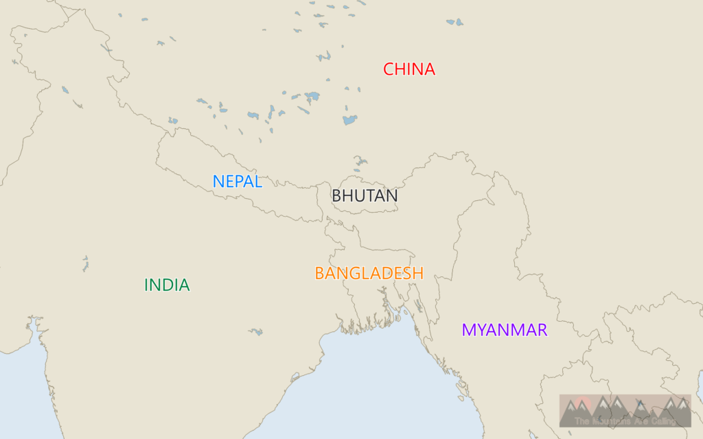


Residents of the Trishuli Valley wouldn’t have contemplated flooding on the morning of August 26, as no rain fell.
But at 8:37 AM local time, a large earthquake shook the area. Tremors aren’t rare in the Himalaya; in 2015, a gargantuan temblor hit the world’s highest peaks, causing avalanches and rock slides that killed thousands, including 22 on Mt. Everest.
The 2026 earthquake registered at magnitude 5.2, a large quake, but it was also unusual: the event wasn’t tectonic.
Moving plates and angry faults didn’t trigger landslides. A landslide triggered the vibrations. This fact begins a chain of incomprehensible scale. Falling rocks caused an earthquake large enough to register on seismographs around the planet.
Scientists believe the slide originated on the flanks of Langtang Lirung, the 99th-highest mountain on the planet and the tallest in the Langtang Himal range. A piece of glacier detached from the crag and crashed down the slopes.
How much rock and ice would produce a magnitude-5.2 earthquake?
Satellite imagery gives us a clue.

A side of the mountain is gone.
Still, from afar, the scale might seem inconsequential. Researchers estimate the length of the displacement to be 600 meters or 2,000 feet (some estimates point closer to 4750 feet, approximately 0.9 miles).
The area that broke away is approximately 49 acres. That’s 65 American football fields. Or 10 New York City blocks. The bases of nearly four examples of the Great Pyramid of Egypt could fit in this footprint.
Needless to say, the mass of such a mountainside would be gigantic. Some estimates put the rock and ice at 55 million tons. This equates to about 4.2 million school buses, or 150 Empire State Buildings, or the mass of 9 Great Pyramids of Giza.
Obviously, anyone in the path of such a landslide would stand no chance of survival, but once again, something was odd about this one.
The slide was so big that the friction caused by the 4,000-foot vertical drop melted the water. The glacier, trapped as ice for millennia, suddenly became a torrent of water, packed with boulders the size of houses.
The area prone to destruction suddenly grew from a landslide field to an entire river system.
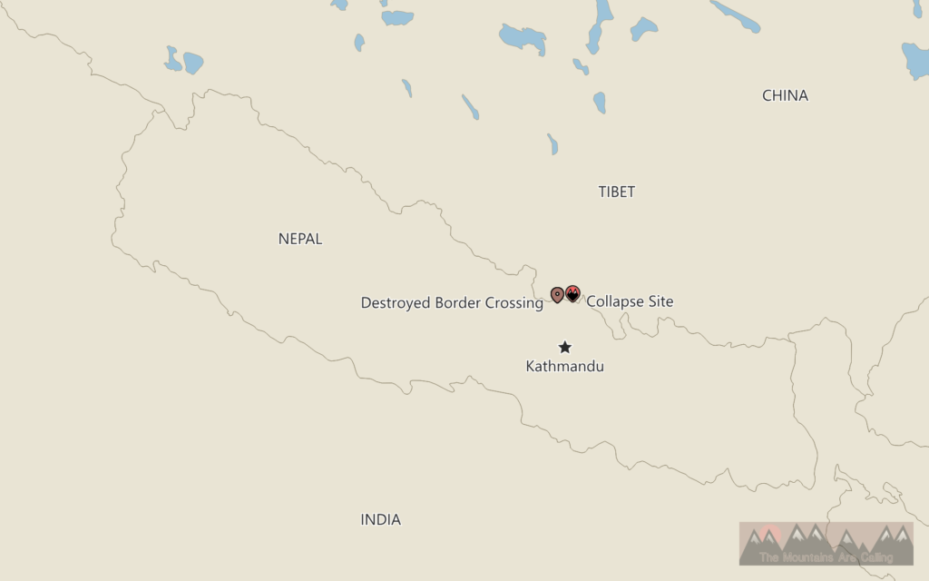
About 14 miles downriver sat Gyirong Port, a border crossing checkpoint between Chinese Tibet and Nepal. Travel and trade have poured through this region for thousands of years.
Before the 2026 flood, a 65-foot (20-meter) structure marked the national border.
Gyirong Port serves as the first location where we can see the scale of the disaster. Surveillance footage from the site resembles a science-fiction film. Water doesn’t slowly inundate the gate; it instantly overwhelms the massive building with elemental fury.
The footage displays people scrambling in vain toward safety. Some head away from the river, while some seek shelter in the building. Their decision didn’t matter.
The torrent tosses tour buses like they’re feathers. The edifices crumble within seconds. Water, rock, and mud pour over the port building as if it weren’t there.
Researchers estimate the cascade took about seven minutes to traverse the 14 miles, meaning it was moving at over 100 miles per hour.
The terror must have been instant and debilitating for the unfortunate humans there. What sort of sound preceded the flood as it thundered down the valley?
I’ve never seen any footage like it. After the water hits, the mind expects it to end, but it just continues. And continues. Even the biggest tsunami video seems to hit with less rage.
In the aftermath, the port’s region is scoured to bedrock.


The debris left evidence that defies everyday reality.
About four miles from the glacier collapse, discoloration shows the event’s wave reached 2,600 feet (800 meters) above the valley floor! That’s nearly half a mile, double the height of the Empire State Building and just short of the world’s tallest building, the Burj Khalifa.
Further down the river, villages more than 270 feet above the river – usually an elevation safe from the wildest flooding – saw their confines breached.
Silt from the flood reached nearly five feet, making search and rescue nearly impossible.
The original debris array flowed for more than 60 miles, but the rubble’s overall scope dwarfs that figure. More than 2.2 million tons of destruction moved downstream. Bodies were found 150 miles away in India!
Everything – bridges, roads, houses, power structures – in the flood’s way, gone.
Together, the three videos above give us a sense of the event’s massive scale.
The first displays the utter power of the surge. It’s like an inland, moving ocean.
The second provides insight into just how high the volume reached. At the beginning of the video, the thought of water reaching the cameraperson seems unfathomable. Yet, by the end, water smacks over the railings.
And the final footage zooms out to illustrate how we’re working on mountainous scales. At first, the flood moving down the river seems minor, until you realize this assessment is simply a trick of perspective. The viewpoint is gargantuan, only truly revealed at the end, when everything below is obliterated.
These videos seem unrivaled in recorded history.

In awe of the physical damage, we can easily forget the human toll.
Each person in the videos above had a family and a vibrant life. Nearly everyone in this valley will now live a suddenly altered existence, if they were lucky enough to survive.
By mid-September 2026, more than 1,400 people have been confirmed dead due to the flooding. This number vastly undercounts the actual figure, as more than 5,000 people remain missing. Most of these humans will never be found or identified, thanks to the grisly force of the disaster. If the flooding occurred in a more populated region, the death toll would have been catastrophically higher.
This event might seem to be a freakish aberration, but disasters of this scale might become more and more common.
The glacier’s unloosing reflects a warming planet. The ice on Langtang Lirung had been frozen for thousands of years before reaching a breaking point.
As we continue to heat up, we must learn from these events. We can’t look past them. How often will they happen? Where will they transpire next? How will we prepare?
Further Reading and Exploration
Nepal floods of 2026 – Encyclopedia Britannica
What caused the catastrophic flood in Nepal and Tibet – and how does a glacier collapse? – The Guardian
Landslide Along With Glacial Collapse Likely Set Off Nepal Flooding, Scientists Say – New York Times
2026 Nepal Debris Avalanche and Flash Flood – USGS
M 5.2 Landslide – 55 km NW of Kodāri̇̄, Nepal – USGS
The worrying climate link to Nepal’s avalanche and flood catastrophe – Yale Climate Connections