
Adam’s Bridge
One of the gorgeous macro-elements of the globe is the island of Sri Lanka, which seems to fall like a teardrop from the southern tip of India.

About the size of West Virginia and home to 22 million people, Sri Lanka features interesting tectonics and geography. Madagascar, for the sake of comparison, sits somewhat similarly off the coast of Africa. Yet, the world’s fourth-largest island rests on its own plate, providing at least some context for why a massive isle is so close to a continent but not part of that landmass. Sri Lanka, on the other hand, is part of the Indian Plate. As India separated millions of years ago from the ancient continent of Gondwana, Sri Lanka’s land went with it.
Traditionally, the teardrop island has been a major cog in international trade routes. It was integrated into the ancient Silk Road and is part of the so-called Maritime Silk Road of modern times. This status arrives thanks to the fantastic natural harbors on the eastern edge of Sri Lanka. The water becomes deep very quickly, especially at Trincomalee Harbor, one of the largest natural harbors on the planet. There, in under a mile, the sea canyons reach depths of up to 4,000 feet. Placid surface conditions, wide berths, and no risk of grounding have made Trincomalee a major port for as long as humans have sailed.


But not every part of Sri Lanka’s coast is effectively bottomless.
On a globe, it can be difficult to tell how far apart two nations or attributes are. Madagascar is slightly more than 250 miles from Mozambique; Zoomed out, Sri Lanka is much closer to India, approximately 33 miles at the closest point.
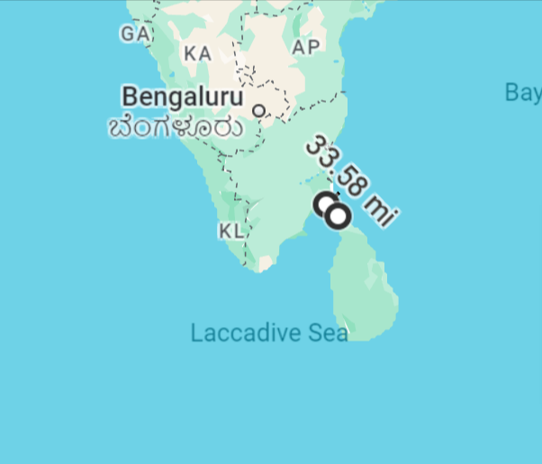
Though we’ve seen that island neighbors can be separated by deep water, such as those along the Wallace Line (and, though Madagascar is 250 miles from Africa, the seas reach a depth of 10,000 feet in that stretch), if we zoom in on Sri Lanka, we’ll see something else going on entirely.
You might ask yourself an important question: if Sri Lanka is part of the Indian Plate, was it always an island or was it perhaps once connected to the subcontinent?
The map begins to answer this query:
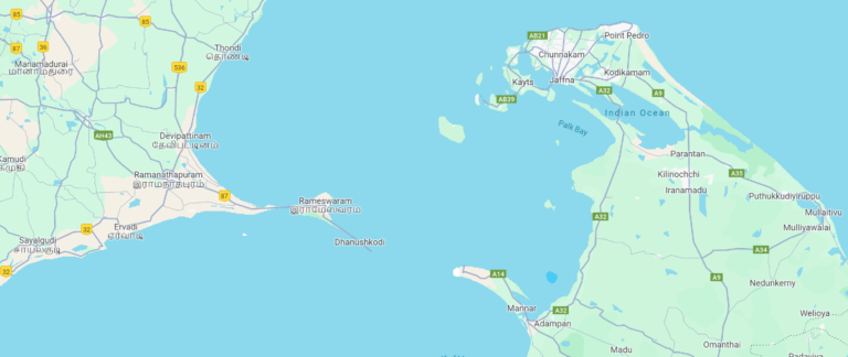
These landmasses are much closer to each other than the wide view indicated. Further, offshoots from both sides seem to be reaching toward each other.
Each time we zoom in, the reality becomes a little more explicit:
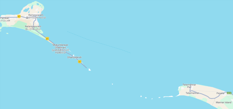
What begins to emerge is known as Adam’s Bridge or Rama’s Bridge.
Between Mannar Island in Sri Lanka and Pamban Island (also known as Rameswaram Island) in India is a series of limestone shoals, some of which peek above the seascape. For 30 miles along the shoals, the depth of the ocean often remains less than three feet! On one side of Sri Lanka lays thousands of feet of harbor-ready sea, while the other side is nearly unnavigable. Adam’s Bridge separates the Gulf of Mannar to the southwest and the Palk Strait to the northeast. The gulf features an average depth of 19 feet, while the strait totes a mean reading of about 60 feet.
Viewed from above, the mass could pass as a legitimate bridge.


This imagery and the “bridge” nomenclature beg the question: was this bridge ever solidly connected from Sri Lanka to India?
The Geological Evidence Magic 8 Ball says: all signs point to yes.
During the Last Glacial Period, which ended about 12,000 years ago, sea levels were as much as 400 feet lower than they are currently, as much of the globe’s water was locked in ice. This difference was enough to expose the bridge and the surrounding gulf and strait. Most likely, Sri Lanka looked like a major Indian peninsula. As the glacial age ended, oceans began to rise, slowly submerging the surrounding areas before gobbling large portions of the bridge.
According to documents in local temples, the bridge remained complete until 1480! The records indicate that major storms inundated the area, sending much of the bridge underwater, where they have remained since. No geological evidence can support this temporal tale, but, if true, one could have walked from India to Sri Lanka around the time of Christopher Columbus.
The origin of the name of the bridge is fascinating. Many times, when a designator such as “Adam” adorns something in a non-English part of the world, the coronation is one of imperialism. This notion is far from a stretch, as England claimed India as a colony until 1947. However, the Adam in question is not British but Biblical. In Muslim tradition, after Adam was booted from the Garden of Eden, he fell to Earth on Adam’s Peak, which just happens to be in Sri Lanka. The earthbound being headed for India, crossing a bridge which now bears his name. Documentation points to the usage of this name at least as far back as circa 1030 CE.
The other moniker – Rama’s Bridge, or sometimes Rama Setu – arrives from the Sanskrit epic Ramayana. In the tale, the god Rama constructs a bridge to reach the island of Lanka, which many logically attribute to Sri Lanka. Setu is Sanskrit for “bridge.” Because of this tale, some in India and Sri Lanka believe the shoals to be human creations. However, no geological evidence exists to point toward any human or divine intervention in the specifics of Rama’s Bridge.

Should sea levels ever fall, one might be able to stroll between the two nations once again. Unfortunately, that prospect does not look bright for the humans currently inhabiting Earth. Projections peg global sea levels to rise between two and five feet by 2100, meaning Adam’s Bridge could disappear, becoming part of the sea.
Further Reading and Exploration
Adam’s Bridge – Encyclopedia Britannica
Evolution of Ramasetu region as a link between India and Sri Lanka during the late Pleistocene and Holocene – Quaternary Research
Trincomalee Harbor – Global Security
Space photos no proof of Ram Setu: NASA – Hindustan Times