[note: for an interactive, whimsical map depicting the Presidential Range, point your browser here]
The Appalachian Mountains stretch approximately 1,500 miles from Alabama into Canada. Along that varied distance, geologists carve them into subranges, amongst which are the White Mountains. This range covers a large portion of New Hampshire and glances into western Maine. We further divide the White Mountains into smaller ranges, including one of the most famous in the United States: the Presidential Range.
The Presidents possess the highest peaks in the White Mountains and the northern portions of the Appalachian system in the United States. They also feature some of the world’s worst weather!
A map of the Appalachian subranges in the Northeast - White Mountains denoted by "W" - graphic by Pfly
The harsh crags of the White Mountains have fascinated humans for millennia; early European settlers were no different.
They named the tallest mountain in the Presidential Range, Whites, and state of New Hampshire after then-General George Washington. Of course, Indigenous humans called this peak something else entirely: Agiocochook. That moniker is an Abenaki word meaning “Home of the Great Spirit.” By the 1790s, European hegemony had already arrived, so the Washington nomenclature stuck.
Since George Washington had not yet become the first president of the United States, the notion of a Presidential Range would have been completely alien to the aliens of New England. That idea arrived in 1820 when a group decided to continue naming mountains in this range after presidents.
Mount Washington - photo by Harvey Barrison
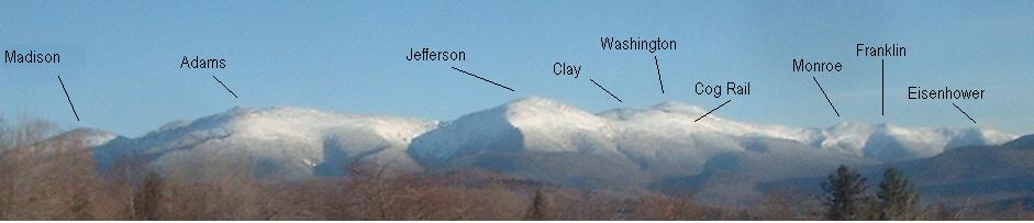
Since the tallest honor went to the inaugural president, the second-highest peak became Mt. Adams. The next in line became Mount Jefferson, followed by Mount Madison and Mount Monroe. That completed the list of possible presidential inspiration in 1820. Yet more mountains remained in the range. So, they dubbed one Mount Franklin, after Benjamin. Sam Adams and Daniel Webster got their peaks, as well.
In the 20th century, Franklin Pierce found himself inside the range, taking over the mountain formerly named Mt. Clinton, after DeWitt Clinton, a governor of New York. Mount Pleasant evolved into Mount Eisenhower. John Quincy Adams joined his father, gracing a subpeak of Mt. Adams. Another acme of Mt. Adams garnered the name Mt. Abigail Adams.
The range proper contains 13 crags, of which nine rise over 4,000 feet above sea level.
A portion of the Presidential Range - graphic by Lupinelawyer
The Presidential Range is renowned for its ruggedness. Some of the Northeast’s toughest mountaineering happens on these peaks. A celebrated feat, called the Presidential Traverse, crosses the apexes of all the tallest mountains in the range. It’s 19 miles of arduous beauty.
Some of the most gnarly adventurers attempt the traverse in the winter. This undertaking is extraordinarily perilous. Many lives have ended in the Presidential Range. How can mountains, which only ascend 3,000 to 6,200 feet claim so many lives?
The weather.
Photo by Sayden
The region suffers from some of the worst weather on the planet.
Things get so bad on the summit of Mount Washington that researchers erected an observatory there to document the extremes. In 1934, winds hit 231 miles per hour, a record for the face of the planet outside of tornados and hurricanes. High winds are a feature, not a bug, in the White Mountains. My parents witnessed a man blown off Mt. Washington on a visit before my birth (he survived!).
Winter in the Presidential Range resembles much higher world peaks. Because of this similarity, many trekkers use the White Mountains to prepare for summiting the tallest mountains in the world.
Enjoy some images from this gorgeous set of mountains!
A buidling atop Mount Washington - image attributable to BenFrantzDale
Mt. Adams - photo by Paulbalegend
Mt. Eisenhower - image by Canderson7
Mt. Jefferson from Mt. Washington - photo by Paulbalegend
The Presidential Range from afar - photo by 1HappyHiker