Ohio is one of just five states that intersect with one of North America’s major rivers and a Great Lake (Minnesota, Wisconsin, Illinois, and Indiana are the others). Its eponymous river forms the southern border, while a large part of its northern edge abuts Lake Erie.
The lake is named for the Erie people, an Indigenous tribe that lived along the shores when Europeans arrived in the region. Though the etymology is not definitive, the name Erie comes from the Iroquois word erielhonan. This term means “people of the long tail.” Though experts believe the Iroquois name for the Erie is related to specific Indigenous mythological creatures – bobcats, panthers, or lions, which might have had human faces or lived underwater – French explorers took the meaning of “long tail” simply to mean “cats.” So, they called the Erie the Nation du Chat or Chat, meaning “Cat Nation” or, simply, “Cat.” In place of Lake Erie on many early French maps is the name “Lac du Chat,” Lake of the Cat. Somewhere along the way, we dropped the feline interpretation, adopting the tribe’s name for the lake.
Range of the Erie people at the time of European colonization - graphic by Davius and Ogrebot
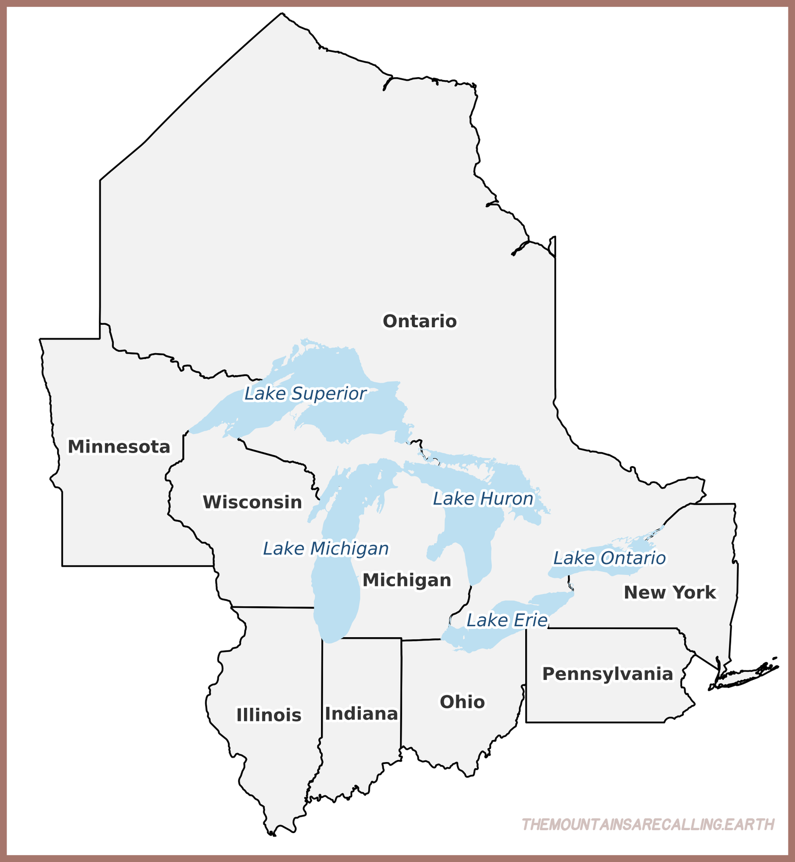
Erie is one of the pentad of Great Lakes, along with Huron, Ontario, Michigan, and Superior. They are the largest group of freshwater lakes on the planet, containing 21% of Earth’s fresh water.
Of the five, Erie is the fourth-largest by area, 9,910 square miles (25,700 square kilometers). Its size ranks 11th globally. Roughly east-to-west, Erie stretches 241 miles, while its breadth is 57 miles. Erie is the shallowest of the Great Lakes, with an average depth of just 62 feet. This dearth of depth means Lake Ontario, which is smaller than Erie by area, contains more water, relegating Erie to fifth in volume. The body still contains a staggering amount of liquid, enough to rank as the 19th-largest lake in the world by volume.
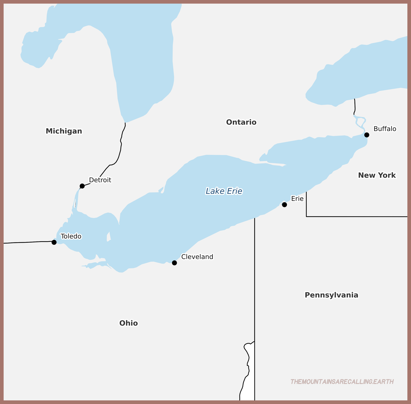
Lake Erie borders four American states, New York, Pennsylvania, Ohio, and Michigan, and one Canadian province, Ontario.
The major port cities all sit on the American side, thanks to the lack of rivers flowing into the lake on the Canadian flank. The biggest are Detroit (via the Detroit River), Toledo, Cleveland, Erie, and Buffalo.
The Great Lakes, with Erie highlighted in dark blue - graphic by Phizzy/TMAC
Since the Great Lakes are some of the largest, we might assume they are ancient bodies. Lake Erie’s current form is extraordinarily young, and not just by the geological terms we often employ.
Over the millennia, multiple lakes formed in an ancient river basin as glacial advances carved bowls in the bedrock, retreated, and dumped their meltwaters. With each new wave of ice, the previous lake disappeared, though they all featured different volumes, allowing geologists to see the edges of each in the lithographic fingerprint.
The last ice age ended approximately 15,000 years ago, which began the formation of Lake Erie. Some geologists believe the glacial aftermath did not settle until approximately 4,000 years ago. Not only is this timeframe shockingly modern on a geological scale, but also young on a human scale. Many cities in the Middle East were founded before Lake Erie looked like it does today. Jerusalem, for example, has been continuously inhabited for over 5,000 years.
Erie’s geology caused another interesting phenomenon. The bedrock in the central and eastern portions is shale, which is significantly softer than the dolomite and limestone in the western part. The glaciers were able to carve significantly more from the eastern portions, which means the western areas are much shallower. The western basin touts an average depth of just 25 feet (7.6 meters)!
Not coincidentally, all of Lake Erie’s 31 islands reside in the west. The largest is Pelee (pronounced by Canadians as PEE-lee), which covers 16 square miles (42 square kilometers). On the American side, the most prominent isles are Kelleys and the Bass trio (North, Middle, and South). In 1813, the Battle of Lake Erie transpired near Put-in-Bay, Ohio, which is on South Bass Island. The skirmish, in which Oliver Hazard Perry led Americans to victory over the British, gave the United States lasting control over Lake Erie.
Lake Warren, a predecessor to Lake Erie - Frank Leverett and Frank B. Taylor
Lake Erie depth map - graphic by Darekk2
Lake Erie's islands - graphic by Frank12
Aerial view of Kelleys Island - photo by Derek Jensen
Evidence of glaciation at Kelleys Island, known as striations - photo by Ser Amantio di Nicolao
Lake Erie’s relatively low volume of water makes it more susceptible to change compared to the other Great Lakes, both natural and human-made.
Erie heats up rapidly in the summer, sometimes reaching 85 degrees Fahrenheit, and cools quickly in the winter, often freezing completely.
These swings are double-edged weapons. The warmth allows for more aquatic life than any other Great Lake; Erie produces more fish than its siblings. If the water gets too hot, though, normal life cannot be sustained, and unwanted outcomes occur. Thanks to rising global temperatures, agricultural runoff, and industrial pollution, the lake has developed large swaths of algal blooms in the past several decades. These unfortunate incidents lead to pockets of low oxygen, often called dead zones. At times, some scientists have classified Lake Erie as “eutrophic,” essentially calling it a dead lake.
The extent of algal blooms in 2011 - NASA
In addition to the effect of unclean water on human health, hundreds of species of fish, birds, insects, and even rare snakes rely on this habitat for their existence. Thankfully, clean-up efforts and legislation, including the Great Lakes Compact, have become more common since the turn of the century.
In winter, Erie is a lake-effect snow monster. Cold air flowing west-to-east moves over the warm water, gathering moisture and rising. As it gets higher, the warm air cools, the water condenses, and it can dump enormous amounts of snow on the eastern portions of the lake. Cleveland, Erie, and, in particular, Buffalo receive many feet of snow each year thanks to Lake Erie. Buffalo receives an average of 95 inches!
Because Erie freezes over, lake-effect snow usually ceases at some point during the winter. The first portions of the season produce far more snow than the latter.
As water moves into Lake Erie from Lake Huron via the Detroit River, it spends an average of 2.6 years in the lake before exiting in the east toward Niagara Falls and Lake Ontario.
The lake’s geographical layout also tends to match North American weather patterns, producing an interesting water phenomenon. As southwestern winds move across the lake, the eastern areas of the lake rise, while the western portions fall. Winds pile the water from the west on top of water already present, forming a wave system called a seiche. One such wind system in 2003 caused the levels in Buffalo to rise seven feet. In addition to 15-foot waves, the city saw a 22-foot inundation of water. Meanwhile, Toledo, where the wind entered the lake, witnessed a drop in water level of a similar scale.
Perry's Victory and International Peace Memorial at Put-in-Bay, Ohio - photo by Kevin Payravi
Frozen Lake Erie - photo by GandZ
The West Pierhead Lighthouse in Cleveland, Ohio - photo by Mtbangert
Lighthouse at Headlands Park in Mentor, Ohio - photo by Ed Cummings
Humans have lived and loved this volatile, gorgeous inland sea for hundreds and, likely, thousands of years.
With good stewardship, we can admire the Lake of the Long Tail for many millennia to come!
BONUS FACT: Despite not sitting directly on Lake Erie, many meteorological lists put Syracuse, New York, as the snowiest in the continental United States. The city is close enough to get lake-effect snow from Erie, but also farther east than Buffalo, which allows Syracuse to get more weather whipped up by the Atlantic Ocean.