Despite Ohio’s flat reputation, the state sits on the boundary between Appalachia’s ruggedness and the glaciated farmland of the Midwest. The southeastern region of the state is covered with steep hills, stunning gorges, and dense forest.
For example, Nebraska’s Panorama Point – a flat spot on the edge of Wyoming and Colorado with all of 26 feet of prominence – rests higher above sea level than Maine’s majestic Katahdin – a mountain that towers thousands of feet above the surrounding region. Though the Rockies are a colossal range, they have the advantage of starting thousands of feet above sea level at their bases. Moving west toward these mountains, the elevation gradually increases, leaving the Cornhusker High Point rather lofty. Panorama Point bulges above the geoid, while Katahdin begins closer to zero. Similarly, at Campbell Hill, you won’t see any of the spectacular relief of Ohio’s Hocking Hills region, but you will be higher!
The view from Campbell Hill - photo by Fredlyfish4
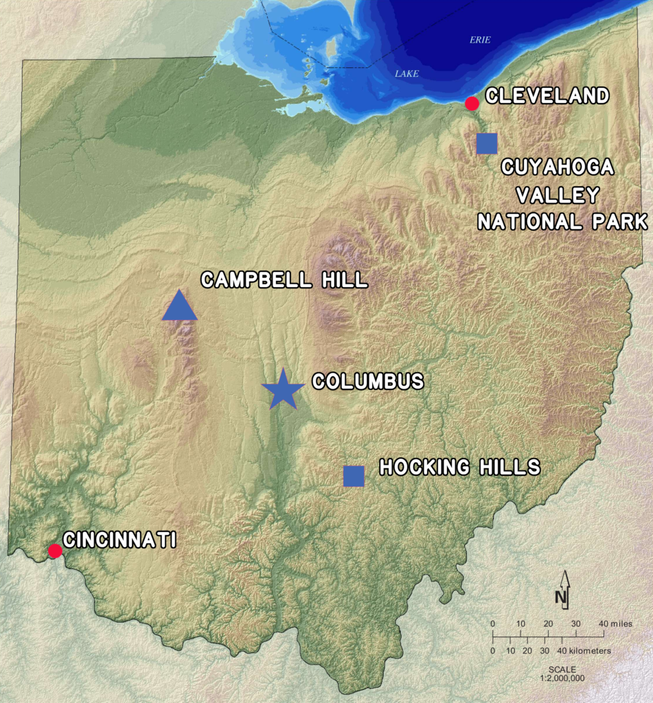
As you can see in the topographic map of Ohio above, elevations dip toward the Ohio River in the south and Lake Erie in the north. Though the western central part of the state is mostly flat, it sits higher above sea level than many other parts with bigger relief patterns.
A band that runs roughly from Campbell Hill to the south stands abruptly higher than the surrounding region; geologists call this band the Bellefontaine outlier. Composed of Devonian era limestone and shale, the outlier resisted destructive glaciation better than nearby areas, leaving it higher above sea level.
Though the massive walls of ice mowed off elevation from western Ohio, the glaciers are also partly responsible for Campbell Hill’s state crown. Approximately 140 feet of glacial till sits atop the Bellefontaine outlier, a rocky, glacial icing on a bedrock cake. Without this extra height, Campbell Hill (and the rest of the outlier’s acmes) would be shorter than a spot called Round Knob, which sits near West Virginia’s northern panhandle and the Pennsylvania border.
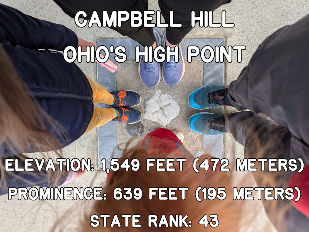
After the glaciers retreated, Campbell Hill stood at 1,549 feet (472 meters). When humans arbitrarily created Ohio’s boundaries, that spot became the tallest in the state!
Though no one will mistake Campbell Hill for a proper mountain, a visit to the location does feel higher than the rest of the region. Traveling toward Bellefontaine, highways rise while fuel economies shrink.
At the site, the promontory juts 40 feet above the surrounding points, producing a lung-busting, if brief, sprint to the peak. You can drive within feet of the apex, but, for those who aim to hike to as many High Points as possible, this little uphill at least gives the impression that you climbed something.
The view isn’t expansive, but what you’ll see at Campbell Hill is interesting. In addition to signage and memorials related to the High Point, large buildings and a massive satellite dish occupy the hill.
A radar dish at Campbell Hill - photo by Kyle Stout
Today, this complex is the Ohio Hi-Point Career Center and the National Air Defense Radar Museum.
How did such an institution end up on top of Campbell Hill?
During the first wave of mass European settlement in Ohio, the High Point was known as Hoge’s Hill or Hogue’s Hill. Significant confusion surrounds this name. Records show the first person to possess a deed for the site was Solomon Rogue. Somehow, the “R” became an “H.” This strange drift leads many online sources to cite the namesake as Solomon Lafayette Hoge, a post-Civil War-era congressperson born in Pickrelltown, Ohio. The same first name and a one-letter difference in the surname must have prompted some head scratching, especially since the High Point presented in the spoken world as Hogue’s Hill. No official connection seems to exist between Hoge and Campbell Hill.
No matter how it became “Hogue’s Hill,” the Rogue family eventually sold the tract to Charles Campbell. The new owner’s moniker became associated with the High Point, saving us all from rogueish bewilderment.
Campbell sold the land to August Wagner, a German beer magnate, who deeded the land to his daughter upon his death. In 1950, Helen sold the land to the Federal Government of the United States, which was engaged in the early years of the Cold War and the opening salvos of the Korean War.
As nuclear capabilities expanded, the United States developed a strategy for defense. What better places for monitoring the skies than lofty spots? In 1951, as part of the Air Defense Command, the government developed Campbell Hill as the home for the 664th Aircraft Control and Warning Squadron.
For the better part of the next two decades, the 664th scanned the heavens for incoming missiles and aircraft. By the end of the 1960s, newer sites emerged with updated technology, eventually morphing into the North American Aerospace Defense Command (NORAD).
In 1969, the government closed the base, then ceded the land to the vocational school. The buildings became a fitting location for a museum about radar defense; the National Air Defense Radar Museum now features displays from around the world.
Enthusiasm abounds at the apex of Ohio - photo by Kyle Stout
Campbell Hill might not feature soaring cliffs and robust relief, but it’s the only state High Point to combine interesting history with a tornado shelter.
Come for the elevation and the museum, knowing you’ll be safe on the edges of Tornado Alley should thunderstorms pop up during your late-afternoon summit attempt.