The Mediterranean Sea stood at the center of the world for many archaic cultures of Europe, Asia, and Africa. To the Greeks, Etruscans, Romans, and all but the most intrepid Phoenician Sailors, the western reaches of the great sea represented the end of the world. This area reportedly bore the slogan Ne plus ultra – “nothing further beyond.”
With this mindset, it’s easy to see how such a place would inhabit the mythologies of these people. Today, we know the western edge of the Mediterranean as the Strait of Gibraltar. The Greeks called the location the Pillars of Heracles, which became the Pillars of Hercules during the time of the Romans. As the story goes, Hercules performed 12 labors in the service of King Eurystheus, the tenth of which required the hero (not today’s usage of the term, but a literal hero, which originally denoted a being with one divine parent and one mortal parent) to snatch the Cattle of Geryon. No easy task, as Geryon was the grandson of Medusa, the nephew of Pegasus, and featured a triple-body (or triple-head) form. The battle for the bovine, says the mythos, transpired at the Strait.
Heracles and the Cattle of Geryones - painting by the workshop of Lucas Cranach the Elder
The “pillar” portion of the title derives from the gorgeous geography of this region.
The Strait of Gibraltar separates Africa from Europe with just 8.1 miles of water. On each side of the strait sits a “pillar.” The Romans called the northern pillar Calpe Mons and the southern Abila Mons. The precise etymology of these terms is unknown. Mons means “mountain,” but the origin of the descriptors might be lost to antiquity. Abila might stem from a Punic word meaning “a lofty mountain,” in which case the name would become redundant. Before we become too judgmental of the poor Romans, many geographical names that involve a foreign language often garner redundancies, such as “Rio Grande River.” The word Calpe came to mean something akin to “monolith,” but some historians believe this word might have originally arisen from the same Punic word, the difference of a guttural. Calpe and Abila could easily derive from the same word spoken with different accents.
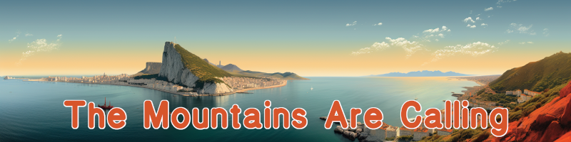
In any case, Calpe Mons refers to the famous Rock of Gibraltar, a towering limestone monolith that guards the entrance to the Mediterranean.
The Rock of Gibraltar - photo by Hansvandervliet
North face of the Calpe Mons - photo by Keith Roper
Rock of Gibraltar - photo by Ian Monroe
Prudential advertisement featuring the Rock of Gibraltar in 1909
This rock packs a lot of fantastic geology. From sea level, it rises 1,398 feet in nearly vertical fashion. The oldest rocks that form Calpe Mons are on top, with the youngest on the bottom. This inversion of the natural law of sedimentation displays that this area has undergone deformity on a gargantuan scale. The rock has been folded, faulted, uplifted, and flipped upside down. Since it’s composed of limestone, the Rock actually sports over 100 caves, including St. Michael’s Cave, a 200-foot network halfway up the mountain.
In addition to the natural draws, humans have also created attractions for the modern tourist. The Moors constructed a castle to take advantage of the Rock’s innate protection. During the Great Siege of Gibraltar in the late 18th century, British forces constructed several underground networks, known as Galleries or Great Siege Tunnels.
Most of the upper part of the Rock is now a nature preserve. This sanctuary is home to 300 Barbary macaques, the only wild monkey population in Europe.
Stalactites in St. Michael's Cave - photo by Schnobby
The Moorish Castle in 1879 - UK National Archives
One of the Galleries - photo by James Cridland
A Barbary macaque takes in the views - photo by AlexCurl
The European pillar is renowned across the globe. Historians cannot even agree which promontory marks the African pillar.
Abila Mons is likely either Jebel Musa, which lies in Morocco, or Monte Hacho, which sits in the Spanish exclave of Cueta. On one hand, Jebel Musa is higher and would command more attention as one entered the strait; on the other, Monte Hacho occupies a stark tip, just like Calpe Mons. The two stare at each other across the water. Jebel Musa rises 2,762 impressive feet above sea level, while Monte Hacho manages 669.
In some versions of the Hercules tale, the hero pushes the two pillars – mountains – apart from each other, creating the strait and connecting the Mediterranean with the Atlantic. In other versions, he brings them closer together, to keep the monsters of the Atlantic from entering his home sea.
The locations of the possible pillars - graphic by Kyle Stout
Jebel Musa, as seen from Gibraltar - photo by Jose Rambaud
Monte Hacho - photo by DMY
Today, it’s hard to find a spot on our globe that displays a wackier political melange than that of the strait.
Other than the points where continents physically touch, the Strait of Gibraltar marks the closest two separate continents come. The eight-mile gap between Europe and Asia was destined to create a hotspot. History has certainly abided. Europeans and Africans have used this strategic location for fortifications and invasion beginnings many times. The administrative makeup of the region displays the tension rather well.
Though the European section of the region lies on the Spanish portion of the Iberian Peninsula, the area that contains the Rock is actually a British Overseas Territory. The British took charge of the 2.6-square-mile chunk of land in 1713 and have held it ever since, despite cries for sovereignty or a return to Spanish control. On the other side of the sea, things aren’t any less weird. The African side of the strait sits in Morocco, except for the city of Cueta, which is an autonomous city that belongs to Spain. The Spanish have held this territory in some form since 1668.
The name Gibraltar is a perfect metaphor for the region. The derivation does not come from English or Spanish, or, for that matter, from Latin or Greek. Instead, Gibraltar comes from an Arabic moniker: Jabal Ṭāriq. This name means “Tariq’s Mount,” after Tariq ibn Ziyad, a Berber commander who crossed the strait and began the Muslim Conquest of Spain in the 700s. At some point, in either Spanish or English, the proper name became corrupted in translation, morphing into Gibraltar.
The odd administration of the land along the strait
NASA satellite image of the Strait of Gibraltar
Europe on the left; Africa on the right - NASA
The reasons for Britain and Spain to desire control of these locations are obvious. In addition to the military value, these sites traditionally held enormous trading significance.
Though the continents don’t touch above sea level, this region is one spot where the African plate and European plate meet. Currently, eight miles and depths of 980 to 2,950 feet separate the landmasses. However, the African plate slowly moves northward. Some scientists believe, based on the current trajectory, that the strait might close in several million years.
The UK, Spain, and Morocco – if they still exist that far into the future – will need to come up with new arrangements if they smash together. The Strait of Gibraltar is another wonderful example of how short humanity’s timescale is in relation to the geology of Mother Earth.