American Stonehenge: The Newark Octagon
In entering the ancient avenue for the first time, the visitor does not fail to experience a sensation of awe, such as he might feel in passing the portals of an Egyptian temple, or in gazing upon the silent ruins of Petra of the desert.
–Ephraim George Squier and Edwin Hamilton Davis, Ancient Monuments of the Mississippi Valley
This was like Jerusalem or Santiago de Compostella. It was a place where people came from miles around, like Mecca. It was a place of pilgrimage, and people were coming here bringing offerings, offerings of thanksgiving for a healing, offerings in the hope of a blessing of some sort. And what they took back with them from their pilgrimage was that spiritual power that was imparted to them at the site, and also perhaps a pilgrim’s token, a souvenir, some badge that says “I’ve been on the Great Haj to Newark.
–Bradley Lepper
I. “Discovery”
After the American Revolution, the newly formed United States turned in earnest toward expanding westward. Beyond the “Great River” lay the Ohio Country, which became part of the first organized region after the original 13 colonies – the Northwest Territory – in 1787.
Europeans pushed into the verdant, unknown land, looking for a new world. Between the Revolution and the dawn of the 19th century, the earliest towns in Ohio took shape. In 1788, along the Ohio River, Marietta and Cincinnati appeared. A slew of settlements in the southern and eastern portions of the state arose shortly thereafter, such as Chillicothe in 1796 and Zanesville in 1798.
In 1800, near the confluence of two branches of the Licking River, a pioneer named Isaac Stadden encountered something incredible in the woods while hunting. Winding through the area was a massive circular embankment with walls that reached 14 feet high at points. Stadden rushed home to his wife, weaving a tale of finding an “Old Fort.” The next day, Isaac and Catherine Stadden returned to the circle, surveying its apex on horseback. Stadden believed he had discovered an ancient military fortification. This interpretation of the structure became the de facto explanation for the circle’s existence. In 1802, settlers founded the town of Newark nearby, and the “Old Fort” became the official nomenclature for the circle.
The “Old Fort” wasn’t the only structure lurking in the Newark area. As people continued investigating the area, they found other earthworks.
A shockingly large number of earthworks.

II. A New World Giza Plateau
In the subsequent decades, locals in the nascent town began to realize more than just the “Old Fort” lay in the woods. Intrepid explorers began to piece together maps in an attempt to catalog what increasingly looked like a gargantuan complex.
In 1820, an antiquarian named Caleb Atwater published Description of the Antiquities Discovered in Ohio and Other Western States, which included the earliest known printed map of what we now know as the Newark Earthworks. In the 1840s, Ephraim George Squier and Edwin Hamilton Davis produced a landmark publication called Ancient Monuments of the Mississippi Valley. This book was sponsored by the Smithsonian Institution and became the first bulletin from their Contributions to Knowledge series. Davis and Squier’s methodology was so rigorous and precise that scientists continue to lean on their maps into modern times. In the 1860s, brothers James and Charles Salisbury continued mapping efforts of the mounds they encountered throughout the region.
What these surveyors located and documented is nothing short of staggering.
Anchoring the mega-structure were the “Old Fort,” a massive square, and an octagon connected to a circle. These geometric mounds were connected by lengthy passageways as if part of a machine. Dozens or hundreds of smaller creations surrounded the main trifecta. The entire structure at Newark seems to have been encircled by an outline row. Taken as a whole, the Newark Earthworks comprised a region of more than four-and-a-half square miles (3,000 acres).
This sizing might be hard to imagine. According to the Ohio History Connection, the Newark Earthworks “could easily have been the world’s most expansive archaeological setting outside the Giza Plateau and the Great Pyramids of Egypt.” The site at Stonehenge would fit inside the massive circle eight times, the Roman Colosseum four times; and the figure’s perimeter would completely engulf Ohio Stadium. The square could serve as the base for the Great Pyramid. The octagon’s walls stretch nearly a mile stacked end-to-end.


What was this sprawling complex in the Ohio woods?
The European settlers obviously had no idea, though they realized the mounds must have been crafted by Indigenous peoples. This 19th-century “discovery” of the Newark Earthworks, framed in a European manner, arrives largely due to the survival of written records, but the tale is hardly limited to white settlers. Indigenous Americans who lived in Ohio seemed to know just as little about the mounds as the Europeans. They certainly were not employing the embankments for any contemporary purpose, but they also did not seem to possess many oral traditions about the sites. This reality is hardly surprising: many of the groups of Native Americans inhabiting Ohio at the time were also emigres. Some had been forced from their lands in the east by the arrival of Europeans, while others had relocated to the region after conflicts with the Iroquois Confederacy. It seemed none of Ohio’s 19th-century groups could claim direct credit for creating the earthworks, suggesting they could be extraordinarily ancient.
If the creators remained mysterious, why had these structures been created?
The idea of a defensive fortification remained alluring. The “Old Fort” and the “Octagon Fort” seemed to be places of solidity, perhaps the bastion of a community or budding civilization. The circle even contained a ditch that appeared moat-like. Eventually, people began to question this military interpretation. Atwater realized the moat lay inside the circle. If not defensive, what was this grand network?
III. Modern America Comes to the Earthworks
As Newark and Licking County grew, the people began to reckon with a land filled with extensive structures.
The “Old Fort’s” 19th-century history is wild.
It became the Licking County Fairgrounds and hosted the State Fair multiple times. It was large enough for a horse track.
In 1861, leaning on the fortification interpretation, the circle became Camp John Sherman, training grounds for the 76th Ohio Volunteer Infantry. Leaving in February 1862, the unit fought at Fort Donelson just six days later. By the end of the Civil War, they had marched 9,000 miles and participated in 47 battles.
In 1878, the circle hosted a Grand Reunion of Civil War troops. President Rutherford B. Hayes, General and future President James A. Garfield, and General William Tecumseh Sherman gathered to give remarks in front of approximately 20,000 alumni. A wooden platform erected for the event collapsed, nearly killing the three famous men, allegedly leading Sherman to remark that a carpenter had nearly accomplished what “400,000 Rebels with muskets failed to do in four years.”
The greatest spectacle of the age visited the circle in October 1884, as Buffalo Bill’s Wild West show hit town. William Cody later touted the mounds in Newark as the “most wonderful” he’d seen.
Between 1896 and 1924, the circle housed an amusement park called Idlewilde, replete with a Ferris Wheel, a proto-rollercoaster, a dance pavilion, and shooting galleries.
Military units also utilized the octagon, as the Ohio state militia camped there from 1892 to 1908. After this period, the octagon became publicly owned, first under the Newark Board of Trade and, eventually, the Ohio Historical Society. In 1910, the plot was leased to the Moundbuilders Country Club, which built a golf course into the mounds.


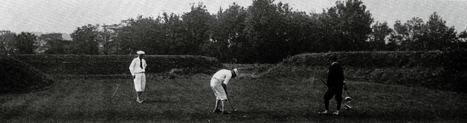

If the notion of golfing, racing horses, housing an amusement park, and hosting reenactments of bison hunts and Native American battles at ancient earthworks seems disrespectful or gauche, the situation was about to get worse.
In reality, one could view these distasteful uses as a mixed blessing. The entertainment value of these places kept them from being razed, a fate that did not avoid the other portions of the Newark Earthworks.
As the canals and railroads came to Newark, as the urban infrastructure expanded, large swaths of the mounds disappeared. Nearly the entirety of the square was flattened. The portions to the north of the square, including a large ellipse, were wiped off the map. The avenues connecting the different shapes, gone. The outline of the system, gone.
At fault was a mixture of ignorance and racism. As the 20th century emerged, we still did not know much about the earthworks. Who had built them? What was their purpose? Did it matter to the public? Many people subscribed to the so-called “moundbuilders myth,” a notion that Native Americans could not have been advanced enough to have created such a vast network, that a lost civilization of enlightened people must have lived in the region in the distant past. Looking past the flimsiness of such a belief, if a lost tribe of Jerusalem or the Atlantis civilization had created a mega-system where you lived, wouldn’t that warrant the preservation of its remnants?
The Newark Earthworks suffered under the notion of progress at any cost. What was left had a golf course and an amusement park to thank.
IV. Changing Tides
As the 20th century progressed, researchers began to learn more about the sites.
Excavations, analyses, and historical sleuthing revealed key information. The mounds were likely constructed between 100 BC/BCE and 400 AD/CE by a culture we call the Hopewell tradition. These people were more like a connected network or traders than a single culture or group. The Hopewell tradition occurred during the Middle Woodland period, and they occupied large sections of the continent’s middle and eastern portions.
Most of the embankments did not include bodies, though the ellipse that was destroyed was an ancient cemetery. The majority of Newark’s structures were, it seemed, ceremonial.
As the 1930s approached, many citizens started to believe the sites merited protection. The circle and octagon officially became state property. The “Old Fort” eventually morphed into the Mound Builders State Memorial. The nomenclature gradually evolved into what we call it today: the Great Circle. The state continued to allow the country club to operate the golf course, despite retaining ownership of the land. In 1997, the lease was extended until 2078. The Octagon and Observatory Circle could be visited a few days a year by the public, but mostly remained the domain of members. In 1934, the remaining section of the square was donated to the state by Frances Rees Wright, so they renamed it Wright Earthworks.
By the time these protections had solidified, only 10% of the original structure remained in Newark. Still, at least these portions could persist.

V. Pilgrimage
Even with a decently solidified date range attached to the complex, what was the purpose of these wonderful geometries?
Items discovered during excavations produced a clue.
The mounds in Newark contained items from places that spanned the continent. Copper from Isle Royale and Lake Superior. Shells from the Gulf of Mexico. Mica from Tennessee and North Carolina. Pearls from the Mississippi River. Shark teeth from the Atlantic coast. And, incredibly, obsidian – volcanic glass – from the Yellowstone region!
Evidence suggests the Hopewell tradition featured an extensive trade network over a large sphere of interaction. In some sense, finding these items in Newark is not surprising, as the people of the era moved goods over large distances. However, despite one of the region’s great natural resource centers – the nearby quarry known as Flint Ridge that provided excellent chert – an imbalance existed at Newark: artifacts came in, but they didn’t flow outward. We find things from across the continent at the Newark Earthworks, but not much from Newark in other regions.
This inequality leads experts to believe the Newark Earthworks were a destination of great importance. Pilgrims, they theorize, brought offerings to the great cathedral of their culture. They didn’t take much in terms of souvenirs home, other than blessings and experiences.
Archaeologist Bradley Lepper, one of the leading scholars on the Newark Earthworks, believes the scope of the structures and the preponderance of offerings equate the site to other major areas we associate with pilgrimage.
To the Hopewell, Newark might have been Jerusalem or Mecca.
One might journey many months, perhaps once in a lifetime, to the great complex constructed of earth on the banks of the Licking River.
VI. Cosmic Geometry
Though the mounds received more protection following the 1930s, they remained relatively understated in the public’s mind.
I grew up in Newark in the late 1980s and 1990s. I cannot recall speaking often about the earthworks with my peers or educators. Of course, we knew they existed, as we drove by them constantly. But, at worst, they were simply there. The golf course almost seemed like a gimmick. Sometimes, people would visit the Great Circle for a stroll or a picnic, but we certainly didn’t muse on the ancient purpose of the embankments. I had no inkling my hometown might have been the go-to cathedral for a culture two millennia in the past.
Would the earthworks capture the attention of children more if they were taught with proper perspective?
If I knew then the notions I have learned as an adult, I forcefully believe the answer is yes. Because, as phenomenal as living in a potential Jerusalem or Mecca of the Hopewell world is, this viewpoint was only a glimpse of the genius that lies in Newark.
In the 1970s, theories emerged about the celestial alignment of England’s Stonehenge. The magnificent stone structure seemed to shake hands with the solstices. Though not everyone is fully convinced Stonehenge was a big clock, the idea seems rooted in evidence and plausibility.
Two Stonehenge skeptics – astrophysicist Ray Hively and philosopher Bob Horn – worked at Earlham College in Richmond, Indiana, a megalith’s throw from the Newark Earthworks. The two collaborated on a course about the history of cosmology. They wondered how they could impress upon their students the amount of rigor and work needed to verify a claim about something like Stonehenge. How precise would calculations and diagrams need to be to display alignments with the Sun or Moon that were not happenstance? Large stone structures can randomly align with the Sun: just look at contrivances such as Manhattanhenge. Two neighboring skyscrapers along a western or eastern front will frame the setting or rising Sun on some day. Perhaps Stonehenge was constructed to mimic the Sun’s position at solstices, but had the claimants done the work to rule out randomness?
In the 1980s, Horn and Hively came to Ohio in the hopes of showing their students how you can find alignments with just about any geometric structure.
An octagon, for example.
At the Octagon Earthworks, the class set about accurately mapping the mounds, comparing them to the Smithsonian’s publication from the 19th century. Then they went looking for solar alignments, convinced they would be able to find some non-intended connections, potentially lending evidence to the hypothesis that those alignments can be found where none was intended.
Try as they might, they found no alignments with solstices.
Though this analysis might seem good for the theory that no intentional solstice alignments existed in Newark, the scholars found it perplexing, noting “the complete lack of even random solar alignments was itself improbable.” Hively and Horn had shown up in Newark with the notion of using it to display a connection between randomness and celestial alignments, but the lack of solar calibration forced them to consider that the earthworks were set up to align with something else instead.
They turned to the other major body of Earth’s firmaments: the Moon.
When they mapped the Octagon to the movement of the Moon, the hits arrived quickly and forcefully.
Immediately, five of the shape’s lines pointed to key moments in the lunar cycle. After a careful analysis of the site, more than a dozen such alignments presented themselves.
Horn and Hively were flabbergasted. Hiding in Central Ohio all these years seemed to be a complex clock set to the Moon. They ran millions of computer simulations in an attempt to see how likely it was that their discovery was random. The computer came back with extremely long odds. The earthworks, according to the probabilities, were created intentionally to line up with the Moon.
Their surprise took a deeper form, too.
The Sun is easy.
Our star swings back and forth like a perpetual metronome. Every Summer Solstice, the Sun rises farther north than the rest of the year; every Winter Solstice, it rises farther south (flip the directions in the Southern Hemisphere). This pendulum is uninterrupted. The Sun simply goes back and forth. Finding its extremes takes some attention, but most civilizations catch on rather quickly.
The Moon, however, is a tricky reflector.
Our satellite’s pattern is anything but straightforward. Like the Sun, each basic iteration – in the case of the moon, approximately a month – swings between a maximum north and south rise. However, unlike the Sun, these extremes do not remain stationary. Watch the Moon long enough and you’ll see that the extremes change. The Moon’s rising and setting spots move like a pendulum, but the pendulum’s extremes swing outward and inward. The Moon reaches these extrema at points we call the Major Standstill and the Minor Standstill. At the Major Standstill, the Moon rises farther north and south than it does at any other point. At the Minor Standstill, its northern and southern swings are at their minimum positions.
One loop of this cycle takes 18.6 years!
Hively and Horn believe they demonstrated that the Hopewell had incorporated the entirety of this cycle into the Octagon and surrounding mounds.
Further, the alignments were incredibly accurate, with an average error to moonrise and moonset data of approximately 0.56 degrees, more accurate than the alignments in Stonehenge!


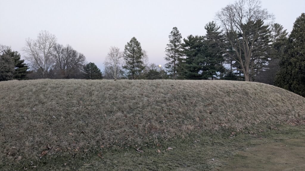
Standing at Observatory Mound, a point at the bottom of Observatory Circle, and looking through the avenue that connects it to the Octagon, one could watch the Moon rise above the opposite vertex at the Major Lunar Standstill, as pictured above.
This sight would have undoubtedly been awesome, but every other extreme in the Moon’s cycle could be viewed along some point of the Octagon’s layout, too.
The discoveries hardly stopped here. Horn and Hively were able to connect the Octagon’s alignments with the other parts of Newark’s complex. The locations of the Great Circle, Wright Square, and other structures were not random at all.
Further, the size of the Observatory Mound seemed to be a base unit in the Hopewell Culture. Its diameter shows up in other complexes (such as major mound groups in Chillicothe, Ohio), and it was used as a measuring stick. From the Observatory Circle to the Great Circle, for example, is six units in length.
Already impressed, the scientists heaped additional praise upon the Hopewell. The setting in Newark would have been incredibly difficult to utilize for monitoring the Moon’s extremes, as it lies in a valley in the Appalachian foothills. Because of this hardship, Hively and Horn continued their research, adding another wrinkle to the tale.
In some ways, their next discovery features sleuth work almost as impressive as the Hopewell’s construction. The researchers wondered how the builders could have been so accurate, despite the relatively lackluster lunar measuring prospects at Newark. So, in the early 2000s, they extended the lines of their calculations behind the Octagon. To their astonishment, they found the math lined up perfectly with four hills on the outside of the valley. When they checked the alignment math from these perches, the accuracy of the builders’ lines improved even more! So, they hypothesized, the Hopewell had observed the Moon at these locations and mapped their findings to the valley.
In researching this topic, I was dumbfounded by the number of times a new layer emerged during their research. Once again, the insights weren’t yet complete.
It seems the Sun was waiting in the machine at Newark all along.
From the four hills, the Summer and Winter Solstices could be traced!


VII. Schematics of Genius
So, it seems, the giant apparatus at Newark mapped the Moon with astonishing precision and even included the Sun. The Octagon served as a moondial of sorts, but the entire system was connected. Combined with the archaeological evidence of pilgrimage, the attributes of the Newark Earthworks point toward it being a site of monumental importance and engineering prowess.
Consider the intellect, process, and tools necessary to construct such a complex in the first few centuries of the Common Era.
The builders would have needed to watch the sky for many decades, perhaps centuries. While the Sun’s extremes might be noted with decent certainty in just a few years, the Moon’s cycle would require generations to hone with confidence. Nearly five Olympiads would pass before the Moon returned to an extreme. Additionally, observers would need to cut out all the “noise” the Moon creates each month. The quick vacillations must be discarded; only the extremes matter.
How did they keep track of this information? We have no evidence of permanent written records from the Hopewell. How did they maintain accuracy over the decades?
How did they transfer their observations from the hills to the flat valley? How did they maintain a “unit” circle? Did this unit arise because of a measurement they made from the skies? Or did the circle’s circumference and diameter predate mound ideas?
How did they maintain straight lines over such long distances? The lengths of the Octagon are one thing, but the lines from Octagon to Circle to Square would require some ingenuity.
How did they build the mounds? How much dirt did it take to construct something so massive? How long did it take?
Was one Hopewellian da Vinci in charge of the vision, or was it a group effort? Did the masterminds live to see their project completed? Or was it like a multi-generational spaceship heading to a distant star, launched by dreamers who never had a shot to see the promised land?
VIII. Time Is a Flat Circle
The intricacy and elegance on display in Newark are staggering.
Why is this location not more famous?
A few reasons stand out.
First, the architecture of this place does not lend itself to photographs or the human psyche. The mounds are not mountains or skyscrapers. They do not jut into the sky like a Great Pyramid or stand starkly above a plain like Stonehenge. They are a horizontal behemoth. Our minds have a difficult time processing this sort of structure. Without context, one can approach a mound and feel a lack of excitement. I’ve watched Newark residents experience this malaise for decades. We are built to appreciate verticality.
Though times and ideas are changing, America’s mounds bring the baggage of our own making. Traditionally, we have not valued or respected the abilities of Indigenous Americans. We have viewed them as lesser. It’s hard to see the brilliance in people we thought incapable of brilliance. We were clearly wrong on this count.
Further, we have not had much access to the Octagon. Though part of its protection can be given to the country club, they also rarely allowed non-members to visit. To really understand the scope of this place, it needs to be walked. An admirer needs to get on the grass and look down the lines of the Moon. Without access, it’s hard to kindle a fire.
Part of the general oversight could relate to the destruction of portions of the complex and its general setting. Imagine Stonehenge partially destroyed, while sitting next to a highway, town, or on a golf course. Would it retain all its magic? Look at a photo of the grand pyramids of Egypt; then look at how close they are to a metropolis. Do they retain the same charm? The mounds in Newark sit in the midst of the 18th-largest city in Ohio. Sometimes, it’s hard to imagine the setting in the first few centuries when cars zoom nearby.
Still, things are looking up for the Newark Earthworks.
As the scientific conclusions of Horn and Hively start to seep into consensus, an appreciation for this place slowly rises.
In 2023, the Newark Earthworks and other mound sites in Ohio became a UNESCO World Heritage Site, the first such designation in Ohio and just the 26th in the United States. This honor cannot be understated. The Hopewell Ceremonial Earthworks join sites such as Yosemite, Yellowstone, the Grand Canyon, the Statue of Liberty, and Mammoth Cave in the USA, in addition to famous places such as the Taj Mahal, Easter Island, the Great Wall of China, and, of course, Stonehenge and the Great Pyramids.
On 1 January 2025, the Octagon opened to the public, as the State of Ohio terminated the lease for the golf course. Hundreds of people gathered to tour the site and listen to experts describe the history of this place.
These two events should preserve this place for the foreseeable future.
In recent decades, Native Americans from across the nation have begun to come back to the Newark Earthworks. Many of their visits are filled with wonder and pride. This place was sacred to the Hopewell, and I can only imagine the feelings I would experience if I returned to such a locale created by my ancestors.
These developments fill me with a sense that we are finally starting to shift the Newark Earthworks toward the modality of their creators. My ancestors did not make these mounds, nor did I revere them as I grew up, despite my proximity. Yet, today, when I visit I feel a connection to humanity, the Earth, and the cosmos in a way I never would have imagined.
In 2024 and 2025, as the Octagon opened to the public, the Moon’s orbit brought it once again to the Major Standstill. A visit to the Octagon, as these words are typed, could present a visitor with the opportunity to see the Moon rise at its northernmost extreme. This chance can align a modern human with those who traveled across the continent millennia ago, watching the Moon come up in its right place.
On the date of the recent total lunar eclipse, my family traveled to the Octagon to watch the Moon rise. The eclipse and the northernmost extreme did not quite line up that day, but we researched where Luna would appear and waited. When our satellite peeked over the mound at the end of the avenue between Observatory Circle and the Octagon, we celebrated, knowing mere hours later it would be eclipsed, turning blood red. I imagined the thousands of people who had done the same thing all those years ago, as well as all the time this great machine sat dormant in human minds. How many Hopewell had watched a lunar eclipse from this spot? I felt glad that my daughters would grow up in an environment that understands the earthworks, unlike my unknowing youth.
We were the only people there that day, which seemed almost criminal. Will the world’s largest set of geometric earthworks ever achieve a Stonehenge level of fame? Likely not, but you can bet I’ll be looking down the Octagon’s lines at the Moon every chance I get.
I recommend you do the same.


Further Reading and Exploration
Hopewell Ceremonial Earthworks – Official Website
Hopewell Ceremonial Earthworks – UNESCO
Newark Earthworks Center – Ohio State University
Newark: The Largest Geometric Earthwork Complex in the World – Ancient Ohio Trail
Earthworks: How we found the lunar alignments at the Octagon – Newark Advocate
A New and Extended Case for Lunar (and Solar) Astronomy at the Newark Earthworks – Midcontinental Journal of Archaeology
The Golf Course – Moundbuilders Country Club
Ancient Monuments of the Mississippi Valley. – Library of Congress/Smithsonian
Description of antiquities discovered in the State of Ohio and other Western States – Harvard University
Centennial History of Licking County, Ohio
A View Within a Circle – Ohio History Connection
A View Within the Circle, Part II: Inside Looking Out – Ohio History Connection
TWO OLDER “NEW” OLD MAPS OF THE NEWARK EARTHWORKS – Penn State University
The Newark Earthworks – Explore Licking County
Transcontinental Travel—2,000 Years Ago – Sapiens