They’re beautiful, those cliffs. In fact, I think it’s more interesting than anything I saw on the Appalachian Trail.
–Grandma Gatewood
The National Parks of the United States display some of the globe’s finest features, but the nation’s natural breadth spreads far beyond the federal system. A handful of state parks contain enough grandeur to qualify as National Parks, such as North Dakota’s Custer State Park, Maine’s Baxter State Park, Nevada’s Valley of Fire State Park, and New York’s Adirondack Park.
Another regional jewel is Ohio’s Hocking Hills.
Etched in the state’s Appalachian foothills is the Canyonlands of the Midwest, a region of stunning gorges, recessed caves, picturesque waterfalls, and soaring cliffs. Perhaps you’ve never heard of Hocking Hills, and might scoff at a comparison to Utah’s undeniable splendor. Utah’s Mighty Five National Parks impart an immediate, visceral reaction to a visitor because their rocky sculptures sit atop scoured, barren deserts, unobstructed, straight to the soul. If you don’t know about Hocking Hills, it’s likely for one of two reasons. Firstly, it’s only a state park, relegating its reach to Ohioans or maybe those in surrounding states. Second, when you drive to the Canyonlands of the Midwest, you won’t see looming spires or grand ravines jumping out as soon as they appear on the horizon.
To glimpse the beauty of Hocking Hills, you must pull back the dense forest curtain and travel downward. You have to travel backward through geological time.
The region’s name comes from the 102-mile river that runs from the northwest to the Ohio River. Today’s Hocking River was once called the Hockhocking, which means “bottle” in the Indigenous Delaware language. At the river’s source, about seven miles northwest of Lancaster, Ohio, the narrow creek resembles a bottleneck as it pours over a waterfall.
The name is fitting, as the features of Hocking Hills are the result of water, and include countless waterfalls and pareidolic carvings.
The gorges and cliffs of Hocking Hills were not the direct result of glacial chiseling, though the ice sheets certainly impacted the region’s creation. On the precipice of the glaciers’ farthest extent, the ancient Teays River, which flowed north, became dammed, forming new drainage systems. As the glaciers melted, their waters coursed to the south, which began a dance with one layer of Ohio’s magic bedrock.
Approximately 350 million years ago, Ohio was covered by a sea, which deposited sediment that eventually became a stratum we call the Black Hand sandstone. Positioned in a narrow band south-to-north, the rock was named for a gorge near Newark, Ohio, where European settlers found a petroglyph of a black hand on a cliff. Water, whether glacial ice, riverine liquid, or rain, is the planet’s main gorge engine. Many forms of rock yield easily to the incessant power of water, but some resist the flowing erosional force better than others (though water still always wins in the end).
And when it comes to interplay with water, Black Hand sandstone might as well have been conjured by an artist-sorcerer.
Graphic by Michael Hansen
Generally, Black Hand sandstone is far more resistant to erosion than the surrounding strata. Its structural and chemical makeup – heavily quartzite – gives it the power to maintain integrity, while other rocks disappear.
Specifically, a few intimate attributes make the sandstone particularly suited to gorge-building, waterfall-crafting, and shape-making. The layer is thick, in places nearly 500 feet, allowing the possibility of soaring cliffs.
Though it’s consistently resistant to erosion, its top and bottom layers are particularly robust. This trait allows waterfalls to develop at the boundaries, as the top and bottom tend to remain, even if the central portions have weathered. This inequality among the Black Hand’s layers creates another lovely externality. If portions of the layer manage to break away in large quantities, it’s the central areas, which can result in the spectacular recessed caves for which Hocking Hills is known.
Not true caves, and also known as rock shelters, these recesses have sturdy ceilings and floors, made of the top-most and bottom-most layers of Black Hand sandstone, in addition to a cave-like opening.
If the stratum is so adept at defying water, how did these Hocking Hills features develop? The answer lies in the one weakness of the sandstone: vertical jointing. Though it has been able to withstand millennia of horizontal erosion, upright cracks form through the architecture for various structural and tectonic reasons. As we admitted earlier, water always wins, given enough time. Water finds these cracks and pours through the sandstone. Over the years, these vertical joints widen, becoming creeks and rivers. From there, the water becomes a chiseler, crafting cliffs, which allow the middle portions of the sandstone layer to fall in tremendous blocks, leaving the recessed caves in their absence.
So, though the jointing causes Black Hand sandstone to finally weather, the result is an otherworldly set of rock art.
Ash Cave - photo by Ramseybuckeye
Rock House - photo by See1,Do1,Teach1
Hocking Hills is filled with wonderfully named locations:
Old Man’s Cave Devil’s Bathtub Cedar Falls Whispering Cave Ash Cave Conkle’s Hollow Rock House Rockbridge Cantwell Cliffs
The centerpiece is the gorge that formed Old Man’s Cave, supposedly named after a hermit, Richard Rowe, who took to living in the rock shelter in the late 1700s and/or early 1800s with his dogs during his elderly years.
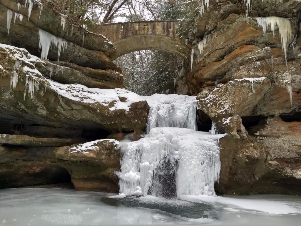
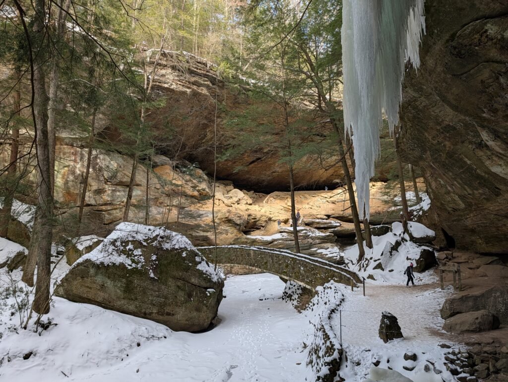
At Hocking Hills State Park, one can walk the length of Old Man’s Creek as it cuts a journey through geological time. Starting at the top of the Black Hand sandstone, the walker descends backwards in time, as the creek goes over Upper Falls, through the Devil’s Bathtub (a spot where the sandstone is so strong that it keeps water from eroding sideways, creating a funneled cauldron), past Whale in the Wall, Eagle Rock, the Sphinx Head, and Turtle Rock, next to dizzyingly big recesses and cliffs, and over Lower Falls, which sits at the bottom boundary of the sandstone.
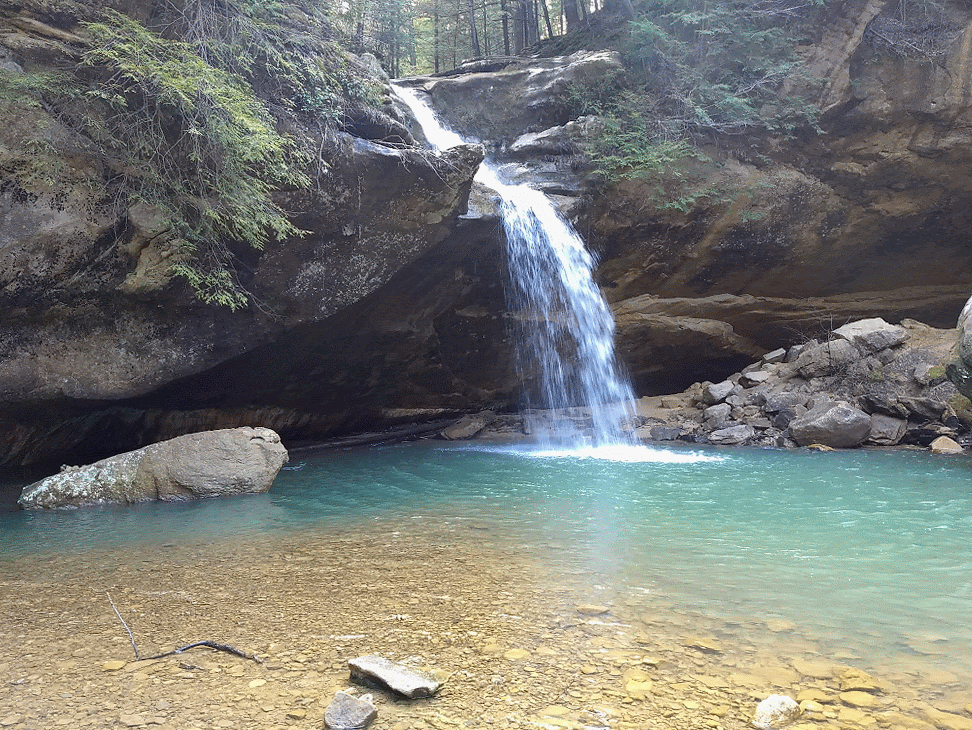
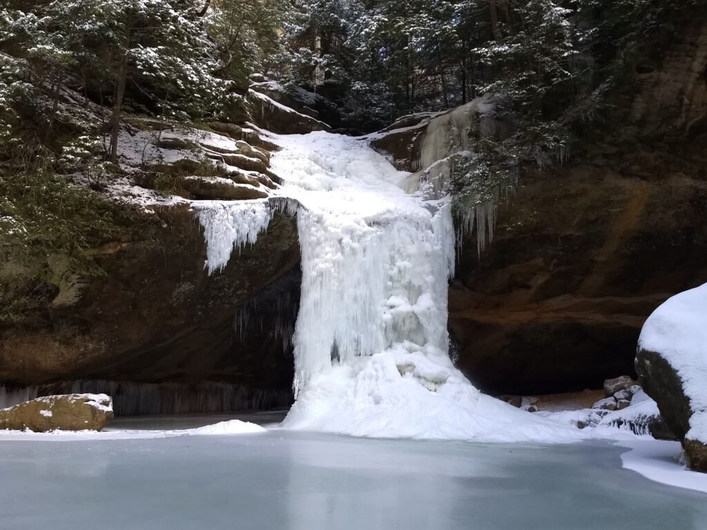
Continuing down the creek, the journey concludes at Cedar Falls, a breathtaking 50-foot cascade that pours over smoothed bowls, forming an enchanting pool.
If you trek through Old Man’s Cave and its gorge, not only do you move through millions of years of rock history, but also ecological history. Though the glaciers did not reach this area, the plants that line the gorge mimic what you likely would have encountered during the Ice Ages, as the cut left a region cooler than usual in Ohio. Soaring Hemlocks, Canadian yews, and bigleaf magnolias stand far outside their normal ranges, as do rare wildflowers and ferns.
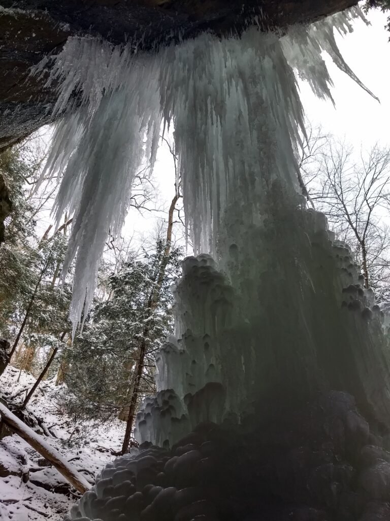
Part of the magic of this watery scar comes from Ohio’s changing seasons. A trip to Hocking Hills varies sharply between winter, spring, summer, and fall. Come in the warmer weather and encounter a lush shire, filled with rushing water; visit in the fall and witness intense color; hike through the winter to see a frozen wonderland, full of stop-motion waterfalls and icy speleothems.
Upper Falls, Old Man's Cave - photo from Ohio DNR
Upper Falls in winter, Old Man's Cave - photo by Kyle Stout
Devil's Bathtub - photo by Bud Schrader
Middle Earth or Old Man's Cave? - photo by Kyle Stout
Lower Falls, Old Man's Cave - photo by Kyle Stout
Lower Falls, Old Man's Cave, in winter - photo by Kyle Stout
Cedar Falls - photo by Kyle Stout
Frozen Cedar Falls - photo by See1,Do1,Teach1
The attractions outside this main corridor are no less enthralling.
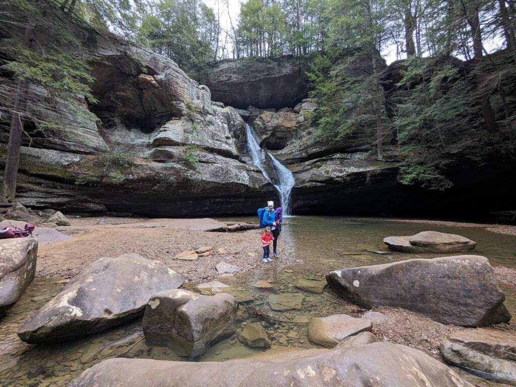
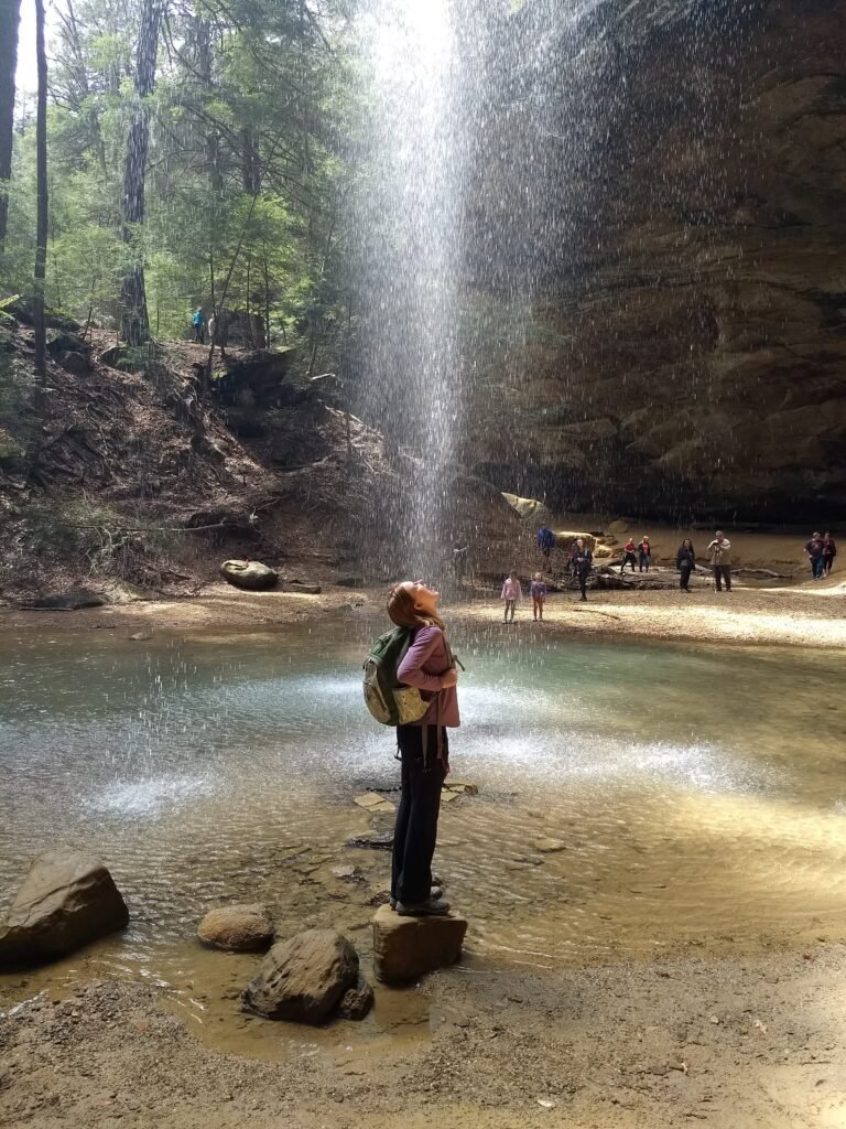
Nearby Ash Cave, so-named because early settlers found ash heaps there, signs that native people had employed the recess cave, is gargantuan. It’s the largest rock shelter in Ohio. Its semi-circular bowl stretches 700 feet, while the nook reaches 100 feet into the Black Hand sandstone. The ceiling stands 90 feet above the floor.
Seasonally, a waterfall flows over the lip.
Another massive recess is Whispering Cave. The hike to this 300-foot-long, 100-foot-high rock shelter moves past vertical walls dotted with honeycombing, a form of weathering that produces hexagonal shapes.
The region’s only “true” cave is Rock House (ironically without the word “cave” in its name), a dazzling abode horizontally eroded into the Black Hand sandstone. Rock House touts a 25-foot-high main gallery that runs 200 feet, with all sorts of stony appliances and popping, natural painted walls. Local legends speak of thieves and outlaws employing Rock House as a hideout, but archaeological evidence displays definite Indigenous usage.
Conkle’s Hollow, one of Ohio’s deepest gorges, contains walls that hit 200 feet.
The most pragmatically named spot in Hocking Hills is Rockbridge, which is a natural rock bridge. One hundred feet long and 20 feet wide, the bridge spans a picturesque ravine.
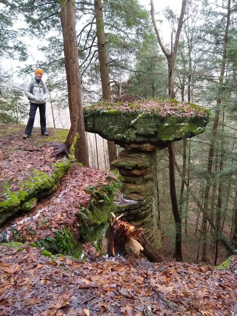
Other fantastic destinations include Balanced Rock, Cantwell Cliffs, and John Glenn Astronomical Park.
Ash Cave - photo from Hockinghills.com
Gathering power from Ash Cave - photo by Kyle Stout
Rock House - photo by See1,Do1,Teach1
Rock House in winter - photo by Kyle Stout
Postcard depicting Conkle's Hollow
Rockbridge - Photo by See1,Do1,Teach1
Balanced Rock - photo by Kyle Stout
Grandma Gatewood, the first woman to solo thru-hike the Appalachian Trail in 1955, was born in Gallia County, just south of Hocking Hills.
With an obvious affinity for the outdoors, Gatewood, of course, gravitated to this area of her home state. In 1967, she began hosting annual hikes through the state park. Today, the trail through Old Man’s Cave bears her name, and more than 2 million people visit Hocking Hills State Park each year.
It’s easy to see why Gatewood was so impressed with these rocks. Though you can’t see the cliffs and gorges of Hocking Hills on the horizon, the intrepid visitor will discover National Park-level nature situated in Ohio’s Black Hand sandstone and southeastern forests.